Wednesday 4 January 2012

Walking the Cassie cattle trail: 5. The final stretch - to Dalway's Bawn

Leaving  Poag's Hill on the last section of my walk with Ray Cowan along the old cattle trail from the Commons to Dalway's Bawn, the 'Cassie' develops a different feel. The final stretch is more wooded as we come near to the edge of the Dalway's Bawn home farm, but at the start, after Poag's Hill, the Cassie becomes obviously well-used - with some new houses behind the occasional 'modern' garden hedge!

 
Thinking we were about to arrive at the end of the Cassie, I was soon disabused of that idea, as Ray explained that these houses were still only accessible from the old lane way - and that the 'road junction' ahead was nothing other than a side lane leading to the old Caldwell and Hay farms among others, including the original Andrew Jackson Homestead (no longer accessible).
Soon we leave this strange,  cluster of side lanes and drives to dispersed isolated houses, and - straight ahead in the above photo - the Cassie reverts to its country lane character.

As we walk down this stretch of the Cassie, it once again feels like a lost, ancient world.
On the left, great views appear of the Bella hill countryside, with another last glimpse of the Irish Sea.
 
The next photographs take us down through a beautiful, wooded stretch signalling that we are now not only down into the 'lowlands' but also on the edge of the wooded margins of the Dalway and Dobbs landscaped demesnes.
   

At the last bend in the lane, a view to the right confirms that we have reached the demesnes of Dalway's Bawn (below the middle horizon) and Castle Dobb's (middle horizon).
And so down the final 100 yards or so of the Cassie down to Dalway's Bawn Road.
 
Out on the road, a last look back up the Cassie
 
- before the photographic evidence that Ray and I have indeed reached the road outside Dalway's Bawn.

Thanks again Ray for the conducted tour. We have reached the end of the Cassie, but not the end of the story! 

Wednesday 21 December 2011

Walking the Cassie cattle trail: 4. Onwards to Porg Hill


Leaving the witch thorn and stories of fairies behind, Ray Cowan and I journeyed on towards the next landmark - a hill rising to over 600ft above sea level, which has traces of a ring fort on its summit. Maybe this 'Porg Hill' was a 'fairy forth'? 

- We'll see!


Walking down towards the bottom of this wide, open  stretch of the Cassie, a new (early 20th century) road cuts across our path. This new road runs from the Beltoy Road to Ballycarry and gives access to dozens of farms that once could only be reached from the Cassie. 
But once over the road, we continued straight on, until we started to climb another short rise towards Porg Hill on the right.    
   The 'new' road just crossed is not shown on the following 1860 map of land holdings, but on the map it can be seen that the fields on the Thomas Hoey farm  (plot 17) run from the Cassie at the witch thorn right down to the house that was the Hoey/Hay farm for generations. This farm belonged to Bob Todd's great, great grandfather as described in the last post. You can see from the map that the Hay family farm was originally accessed from a side lane off the Cassie that originally went on to and through another six or seven farms (including the ancestral home of President Andrew Jackson).         

   
This farm (17a on the map) is still called called 'Beech View', and has been in Hay family hands for over 400 years - as the following account sent me by Bob Todd testifies (it was written as part of a book 'The Hoy's of Maryland' by a Captain Charles E. Hoye, following a visit by him from the US to the Beech View farm which - in 1938 - was owned by Isaac Hay):
"There is a tradition among the Hoys in County Antrim that their ancestor came from Scotland as groom in charge of John Dalway's horses, sometime between 1578 and 1606. As a groom, most of his duties were at the castle and bawn (barn), but in time he leased from Dalway a farm about a half mile northeast of the castle on the hill overlooking the Muttonburn valley. This farm, or part of it, now belongs to his descendant, Isaac Hoy, and the present Hoy home here was probably built by the original Scotch settler.The Muttonburn (burn = creek) flows  south into Belfast Lough northeast of Carrickfergus, draining part of Dalway's  Manor. From high ground near Ballycarry the beautiful little valley is in view, a bit of the Lough and County Down in the distance.
    During the last century Hoys were numerous in the Muttonburn Valley; so numerous and so devoted to such Christian names as James and John that some of the descendants of William and Alexander Hoy changed their name to 'Hay'."
 The map shows that the farm between the Hay's and Porg Hill (18) was owned by John Caldwell in 1860, and indeed the Cassie runs right through this farm. Although Ray Cowan's mother was a Caldwell (and indeed it was her family of Caldwells that bought out Dalway's Bawn and farm about 1900, after Marriott Dalway left for Australia), it appears there were two separate families of Caldwells in Bellahill, and this John Caldwell may not have been directly related to Ray, actually belonging to the Bellahill 'Calwells'. Today these families are distinguished by the spelling of the surname (Calwell and Caldwell) but like many other family surnames in the area, the older records often spell the same person's surname in different ways. Anyway, for Ray, this stretch of the Cassie absolutely 'hotches' with family history.

 When we reach Porg Hill, the Cassie sweeps round to the left, and to investigate it properly a diversion is needed through a gate to the right.

 
Looking back from past this gate that leads up onto Porg Hill, we can see the line of the Cassie running back to the site of the witch thorn on the horizon.

It certainly looks as if the Cassie originally came up over Porg Hill on the side track we are now on.
Approaching the summit of Porg Hill, the outline of the raised platform of an ancient earthen fort can be seen on the horizon ahead. 


And from the top, the remains of a 1,000 year old earthen ring fort are faint but unmistakable. Remarkably, this is not a recognised ancient monument site - or at least I couldn't find any record of it in the Archaeological Survey archives in Belfast. But looking at it in from the air in the satellite photos, again a circular shape is visible.

Porg Hill sits at the center of the Poag farm as it was in 1860 (Thomas Pogue 21 on the map). There were two Pogue (Poag) farms in Bellahill in 1860, both off the Cassie and owned by two brothers, William and Thomas Poag. Although the Poag farm at Porg Hill was owned by Thomas Poag in 1860, it was a James Poag living here in the 1830s when his account of the witch thorn was published (see previous posts), and in 1833 when the Ordnance Survey Memoirs for Bellahill mentions the fort on Porg Hill:
"Fort in Bellahill.
On an eminence in the above townland, and holding of James Poag, there stood a fort 21 yds. in diameter. Some traces of the parapet is still visible." 


But if anyone should doubt that this was an important strategic fort site in ancient times, they should do what Ray and I did, and stand in it to survey the spectacular views of the sea - from Belfast Lough right round to the Irish sea and across to Scotland.
This is the only site I know of in the region where there is such an unbroken view of the entire coastline. The following views take you in a panorama from Belfast Lough to the right, panning left towards the Irish Sea. In the first view, Belfast sits at the head of the Lough, right in the center:


The above photo is looking across the mouth of Belfast Lough, towards County Down. The rough remains of the fort wall are in the foreground.

And in the next photo, the Irish sea can be seen continuously from the mouth of Belfast Lough to the right, to the open sea towards Scotland to the left.


Further left still, and the Irish sea view is only slightly interrupted by the tip of Muldersleigh Hill in the center of the above photo. Muldersleigh Hill, beside Whitehead and the Gobbins Road in Islandmagee, being the final destination of the old cattle trail before the cattle were shipped to Scotland.


Once again I am grateful to a Canadian descendant of a Bellahill exile for filling me in on much of his family history around Porg Hill. This time it is Barry Poag who I have mentioned before. His great grandparents were William and Mary Poag in the center of this family photograph taken in Bellahill about 1900.

 
Four of William Poag's sons also in this photograph emigrated to Canada soon afterwards: Samuel Jackson Poag in 1912, Robert Poag (Barry's grandfather) in 1914, David Poag in 1920, and John Poag in 1921. This amazing exodus of four brothers appears to have been in the wake of their cousin, James McMurtry Poag, who had emigrated to Canada in 1906. 
 
Considering that both Canadian contacts mentioned in this post - Barry Poag and Bob Todd - are descended from the Poag and Hay family farms on this part of the Cassie trail, I am very grateful that they have shared so much of their own family history researches of Bellahill with me from the other side of the Atlantic. But the hub of this genetic wheel of local knowledge is, of course, my traveling guide and old school chum Ray Cowan, whose great, great grandfather John Cowan's farm (not to mention those belonging to the Caldwells and other closely related families in Bellahill), was also part and parcel of the historical context of the Cassie. Yes, the landscape itself speaks, but not so much as the memories of the families that lived in it. 

Just below Porg Hill, at the bottom end of the old Poag 20-acre farm, are the ruins of its farmhouse - marked as 21a on the 1860 farm holding map. Again I am grateful to Barry Poag for sending me this photo of the ruins taken when he visited the site in 2008. 


 So, back to Porg Hill. On the ground, and from the historical records, it is a spectacularly important strategic fort site.

 
The modern map above shows how it dominated the lowland coastal approach of the old cattle trail that had - from the earliest times - lead up to the uplands and commons behind Carrickfergus. As a defensive site, it dominates the Dalway's Bawn 'cattle fort' that replaced it 400 years ago. The broader context in the east Antrim coast can be seen in the next map. See if you can trace the Cassie from the south of Lough Mourne past Porg Hill and down to Bellahill and Dalway's Bawn on this map and the one above.

Some time ago, Barry Poag asked Ray and I what the origin of the name 'Porg' was, and if it could have been a corruption of 'Poag'. 
Well, I think both of us agree that that is the case. There is no Irish Gaelic, Old Norse (Viking) or Ulster-Scots etymology for 'porg' that makes any sense. Even more convincing is the fact that the name does not appear on any old map or document before the late 19th century - by which time it had been firmly located right in the middle of the Poag family farm for at least a century! It is easy to see how a non-local map surveyor might have misheard 'Poag Hill' for 'Porg Hill'. 


But as for fairies on Porg Hill? So far, not a whisper!


Thursday 17 November 2011

Walking the Cassie cattle trail: 3. More light on the Witchthorn

Before moving on from the site of the Bellahill witch thorn and the Witchthorn National School (just past the Resting Slap on the Cassie as described in the previous post), I found some more information which I think is worth relating.

The above-mentioned illustration and account of the Witchthorn from Alexander Johns of Carrickfergus in 1849 is not the only source of information on these. The Ordnance Survey Memoirs for the Parish of Kilroot dated 1839 records that the Witchthorn and the school were on the farm of Thomas Hay, and this source gives the following account of the witchthorn:
"Gentle Bushes 
On an eminence in the townland of Bellahill, and holding of Thomas Hay, there stands a large ancient thorn locally called the Witches' thorn and gave local name to a national school situate at that place. This school is known by the Witchthorn National School.
There are a few other ancient thorns in the parish, and esteemed sacred as being fairy abodes and consequently remain unmolested."
Well, as we saw in the last post, by 1849 branches were being removed and it disappeared before 1900. The title of the OS Memoir account - "Gentle bushes" show that they viewed the superstitions here to be the same as those common throughout Ireland, and related to the "gentle folk" or Fairies. Incidently, a fairy was by no means "gentle" but the term comes from 'gentile' and the Irish "ginte" (gentile, pagan, heathen Dane) - and from which word we get the local family name of McKinty/McGinty (meaning 'son of the Danish man or Viking'). 

As the townland of Bellahill was overwhelmingly Presbyterian, such superstitious beliefs (particularly in fairies) were generally held in ridicule, and so the identification of the tree with witches rather than fairies. In the early 1900s John Hay from this farm in Bellahill told his daughter-in-law (Mrs Susie Hay) a story of how Mr Dalway had ordered the men to clear away an ancient motte-like mound or 'rath' from near the bottom of the Cassie. The hero of the story was a local man who used his sister's tiny clog to make fairy footprints around the 'fairy fort' and play a practical joke on the whole countryside.  Susie Hay then based her ballad, 'The Rath in the Valley' on that story (Note that 'freit' is an Ulster-Scots word for 'superstition' and 'moat' for 'motte' or 'mound' - but in this poem these words are used by the 'English' landlord!):
THE RATH IN THE VALLEY
By Susie Hay

Once upon a time, so I've heard tell,
  A Rath was in a valley, and fairies there did dwell.
None dared molest the "Wee folk" who came when moon was clear,
  And everyone for miles around that Rath did well revere.

The landlord of the valley came unto the mound;
  Said he, "By Irish 'freits' I never will be bound;
That moat doth spoil my field, so to my men I'll say,
  Go at once to that low field, and clear the Rath away."

The men obediently went off, with shovel and with spade;
  Upon that Irish Rath an attack they fiercely made;
But the truth of all the matter was that they were Irish too,
  And the fear of Irish fairies did thrill them through and through.

The first day of their labours, all went very well,
  And nothing but the sound of spades resounded through the dell,
And driving off with carts of mould, they did not their work leave,
  Until above the valley, shone the first faint star of eve.

Lo, see them the next morning, as to their task them come,
  From different cots around the vale, a-straggling one by one,
Scarce wakened from their night's deep sleep, scarce seeing the right
      path,
  But from their stupor quickly roused, when near the Fairy Rath.

The first one who did reach the Rath, to all began to shout,
  "Oh hurry, hurry, hurry, boys, the fairies have been out."
And sure enough, around the mound,--this tale is really true--
  Were marks of tiny footsteps, as of a fairy shoe.

The men were seized with horror; their very bones did freeze!
  And shouts of wild excitement filled the early morning breeze,
And wafted them right up unto the very mansion house,
  To where the lordly master was sitting with his spouse.

"Now what, now what, now what," he called, "is this unearthly row?
  "What's happened that wild Irish crowd, what are they doing now?"
"Oh sir," a messenger replied, who came, all pale with fear;
  "The men won't touch the Rath because the fairies have been here."

So down unto the valley strode the irate English lord,
  Said he unto himself, "I'll quell that Irish rabble horde."
But not a man of all the crowd would ever put a spade
  Into the Rath, the fairy marks had made them so afraid.

When some time passed, so I've been told,
  The work was done by other men, who were by nature bold,
And had no fear of Little Men, Banshee, or Witche's wail;
  But still the "fairy shoemarks" stay an ancient country tale.

The secret of the tale was kept, until 'twas told to me;
  The solution was quite simple, as you will plainly see;
A 'divil-of-a-fellow' a-livin' near the bog,
  Marked all the 'fairy footsteps' with--his little sister's CLOG.
This, and much more, information about the Hays of Bellahill was sent to me by Robert (Bob) Todd of Nova Scotia in Canada, who contacted me after reading the blog.  The Thomas Hay on whose farm the witch thorn stood in the 1839 account was Bob Todd's great, great grandfather. The OS Memoir for 1839 also says that Thomas Hoy (the spellings Hay, Hoy, and Hoey seem to have been used interchangeably for the same person and family) was 'librarian' of the Bellahill Book Club, established in 1837, with 8 members and 23 volumes of historical works. It almost certainly met in the Witchthorn National School, which was also on the 'holding' of Thomas Hay.

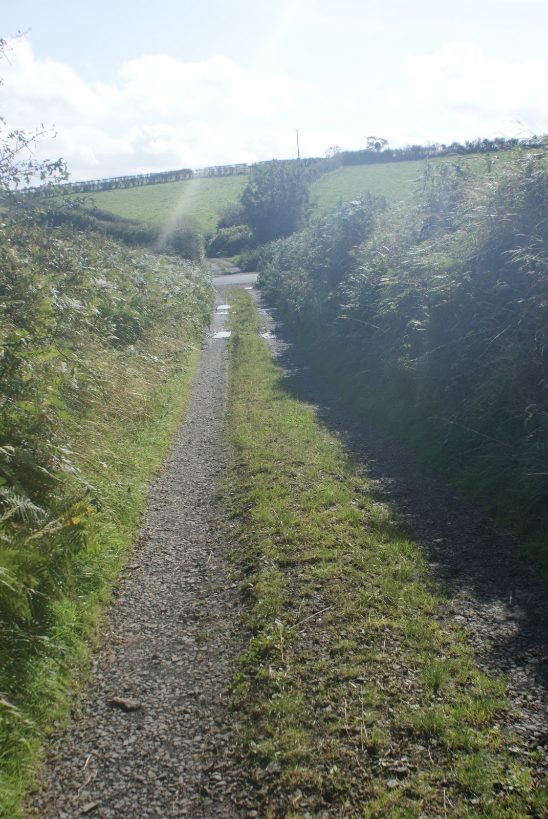
The Witchthorn National School sat on the wide verge on the right-hand side of the Cassie as shown here. In the I839 OS Memoir it is  described as sitting "on the old road leading from Bellahill to the commons".
It was a small, thatched, single-story building, only 18 feet long by 15 feet wide and had been established about 1800. The 16 scholars were all Presbyterian, and the master was a John Saunderson, also a Presbyterian. The school was 'visited' by Rev. William Glendy, a 'minister of the Remonstrant Congregation' and was 'well furnished with desks and forms'.

As we leave the Witchthorn and move on down the Cassie towards Porg Hill, it is quite a coincidence that the history of the two family farms on either side of the cattle trail (the Hay's and the Poag's) has come to life by means of two separate Canadian descendants (Barry Poag and Bob ('Hay')Todd). But more of that soon ...

Friday 11 November 2011

Walking the Cassie cattle trail: 2. From the 'Resting Slap' to the Witchthorn


Leaving the Resting Slap with its views of Belfast Lough and Carrick Castle, the Cassie trail opens up from an overgrown path to a tractor-friendly country lane. My original intention, as promised in the last blog which covered my walk with Ray Cowan from the Beltoy Road to the Resting Slap, was to continue on down the Cassie past the Witchthorn as far as Porg Hill. Porg Hill is where the Poag family farm had been.

There are no Poags still living in Bellahill, but a Barry Poag had read this blog some time ago and wrote to me from Canada (where his grandfather Robert Poag had emigrated to, from here, in the early 1900s).
Over the past year Barry has been corresponding with Ray and I regularly. He has shared a wealth of material from his own family and local history research. There will be much more of these Bellahill Poags when we do eventually reach Porg (or should it be Poag?) Hill. But first of all, Barry has sent some printed information on the Witchthorn - and this opens up a whole new story.


The excerpt is from a book on "The Forest Trees of Britain" published by the well-known English naturalist Rev. C A Johns in 1849. It was supplied to C A Johns "together with the annexed sketch", by the author's uncle, Alexander Johns of Carrickfergus, and it describes the Witch thorn at "Bellahill" on the estate of M. Dalway, Esq. The significance of this discovery for Barry Poag lay in the detail of the account, for Alexander Johns' informant was none other than Barry's great-great-great grandfather James Poag (who indeed states that he remembered the tree 70 years beforehand, that is, in the 1770s!):
"The schoolmaster of the Witch-Thorn National School (the tree has given its name to the place) referred me to an old man named James Poag, residing about a quarter of a mile from the spot. I found him at home, but gained little information; he is 87 years of age, a tailor by trade, and was busy at his work, three lads plying the needle with him; he said his sight was not so good as it had been, and his hearing rather dull! He invited me to take bread and butter and milk, all his house afforded, and told me he remembers the tree for 70 years, and that from his earliest recollection the trunk has always been as large as it is now. Within these few years some branches have been cut off, (a very rare occurrence indeed with an aged Thorn) which being reported to the agent of Mr Dalway, that gentleman went to the spot, and has taken steps to prevent a repitition of the act. The large trunk is 4 feet 2 inches in circumference, and the other 3 feet 6 inches; the thorn is about 20 feet high. It stands on high ground, and the father of the present proprietor told my informant that he had seen the Witch Thorn from the Scotch coast."
The map shows the section of the Cassie from the Resting Slap as far as Porg Hill and the Poag farms in Bellahill, and the sites of the Witchthorn and the Witchthorn National School. Neither of the 'witchthorn' sites survive, although Ray was able to point out the their sites from what he had been told.

Older maps show that the school was there in the 1830s, and it must have survived until the 1870s when the two 'new' Bellahill National Schools were built. These were located on 'proper' roads a t either end of the Cassie (the Beltoy Road, and the Dalway's Bawn Road).


The precise locations of the Witchthorn and the Witchthorn National School are both marked on this detail from an 1858 land valuation survey. A thick red line marks the townland boundary between Crossmary to the south and Bellahill (Ballyhill) to the north and east. Carrickfergus County (North-East Division) is to the west of the Copeland Water.

The thin red lines are farm boundaries - the farm at the top marked 10A is the Cowan home farm, and the one marked 21 bottom right is the 'original' Poag farm.

The Cassie runs across the top of the Cowan farm to the Resting Slap (which is where it meets the top 'point' of Crossmary townland) and then down past the Witchthorn along the townland boundary towards Porg Hill on the Poag farm. The Witchthorn therefore would have been a townland boundary marker before enclosure, not to mention a distant landmark for those on the cattle trail droving towards the 'Resting Slap'. It is fascinating that the 1849 account states that M. Dalway's father told James Poag that the tree could be seen from the 'Scotch coast'.

Alexander Johns had supplied an illustration of the Witchthorn along with his account, and this has to be an actual representation because he describes the tree as having two trunks, one 4 ft. 2 inches in circumference, and the other 3 ft. 6 inches. He also states that the tree was (in the 1840s) 20 ft. tall and that branches had been recently removed which he shows on the ground.
Alexander Johns was born in Cornwall in 1784, and was Ordnance store-keeper of Carrickfergus Castle from 1812. He died in the town in 1866 and was an accomplished illustrator, as his following sketches of Carrickfergus demonstrate. Indeed, he provided all of the original illustrations of local antiquities for Samuel M'Skimmin's "History and Antiquities of Carrickfergus

In the previous post I ended with a photo of Carrickfergus Castle viewed from the Resting Slap, and it fascinates me to think that this was the spot from which Alexander Johns sketched the Witchthorn, after eating a bread and butter 'piece' at James Poag's farm.

Another connection: the Johns' house in Carrickfergus in the 1860s was on the seafront at Joymount where the road leads to the Scotch Quarter, and on to Eden. This photo shows it on the left with a first-floor conservatory. The building (now demolished) was used to house Carrickfergus Technical School when my father was Principal there in the early 1950s.


Back at the Resting Slap, looking back towards Beltoy, is the overgrown path straight ahead that Roy and I had just walked before now proceeding on to Porg Hill. Here the beginning of the wider lane can be seen disappearing into the fields at both sides of the Resting Slap.


As soon as we turn round the corner, the Cassie opens out into a double-width lane, with the worn track only taking up less than half of the total width between the hedges.

And on the ground to the right are the sites of both the Witchthorn and the old Witchthorn National School.

It is not surprising that there is no sign of the school, but because of the superstition against interfering with a 'witch' thorn (the Ulster-Scottish equivalent of the Irish 'fairy' thorn) it is remarkable that nothing of the tree survives. The Scottish beliefs in Broonies (Brownies) and Pechts (Picts) operated here rather than Fairies and Danes. So it was witches, rather than fairies, that were supposed to dance and congregate at these trees - if not live under them! Witch trials were held in Carrickfergus, the most notable one being the trial of the 'Islandmagee Witches' in 1710 when 8 women from Islandmagee (the destination of the Cattle trail) were found guilty in what was to be the last witch trial in Ireland.

And so it's on down the Cassie towards Porg Hill ...